Riverbank Erosion and Social Vulnerability: A GIS-Based Study of the Ganga River
Researchers used GIS-based modeling to assess the social vulnerability of communities along the Ganga River, finding that villages near the Farakka barrage are highly susceptible to riverbank erosion and climate change, necessitating targeted interventions. The study emphasizes the need for tailored social programs and sustainable management plans to enhance resilience in these vulnerable areas.
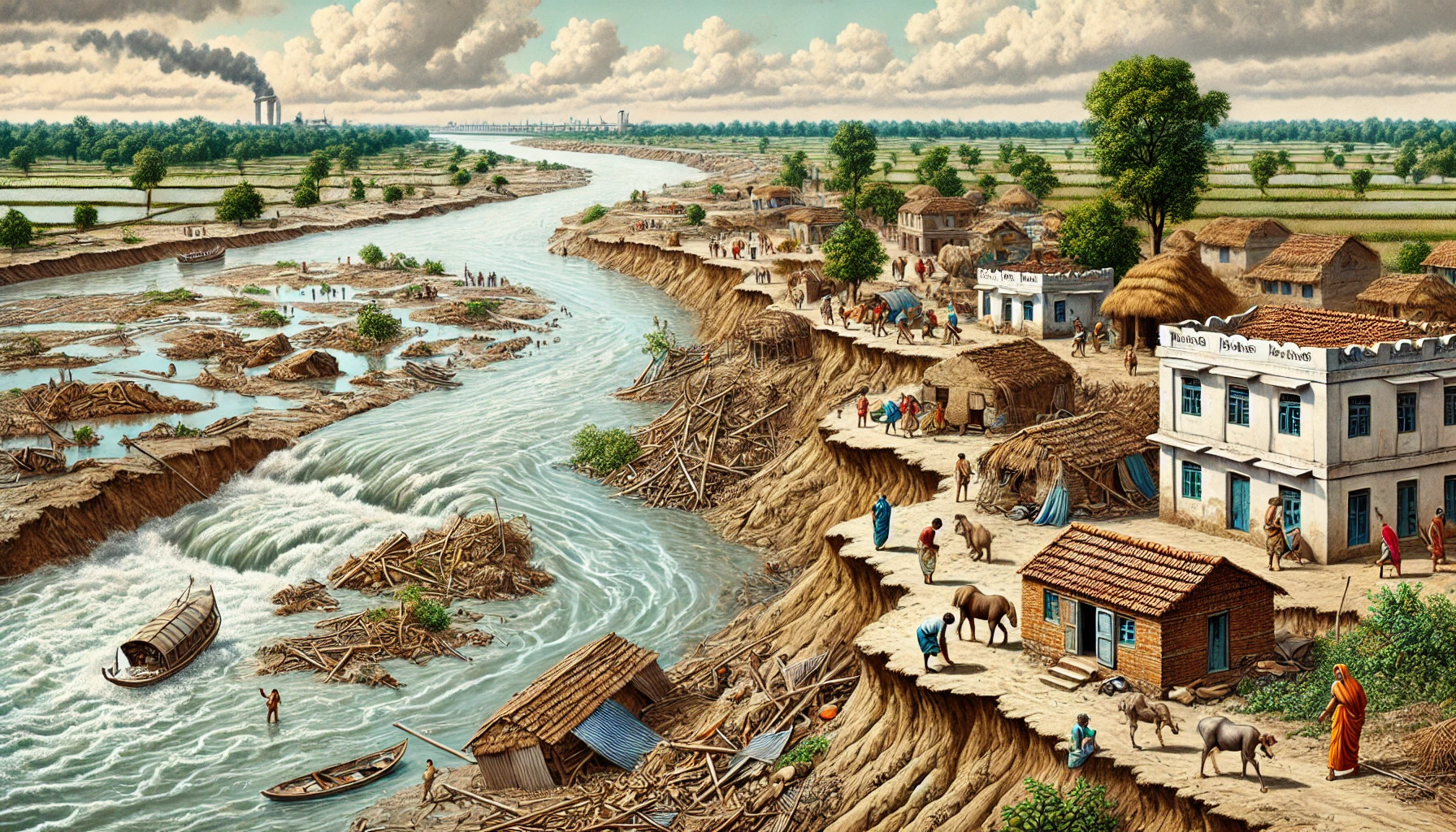
Researchers from Raja N. L. Khan Women’s College, Sidho-Kanho-Birsha University, and Aliah University have conducted a comprehensive study to explore the social vulnerability of communities living along the Ganga River in India, particularly in the lower Ganges region, where riverbank erosion and climate change pose significant threats. Published in Natural Hazard Research, this study employs Geographic Information System (GIS)-based modeling to assess the social vulnerability of villages directly impacted by the continuous and often severe erosion of the riverbanks. The research focuses primarily on the left bank of the Ganga River, especially in areas surrounding the Farakka barrage and char lands newly formed islands that are particularly vulnerable to natural calamities.
Social Vulnerability Index Highlights High-Risk Areas
The study's methodology involved developing a Social Vulnerability Index (SociVI) to quantify the vulnerability of these communities. This index was meticulously constructed by evaluating ten main components and thirty-one sub-components that capture various dimensions of social vulnerability. These dimensions include demographics, educational status, economic conditions, livelihood strategies, infrastructure, access to food and healthcare, climatic variability, and the psychological impact of potential future displacement. To gather the necessary data, the researchers undertook extensive fieldwork across 547 villages, conducting surveys with 1,641 households, facilitating 547 focus group discussions, and holding 12 key informant interviews. This exhaustive approach ensured a comprehensive understanding of the social dynamics and vulnerabilities within these riverbank communities.
Alarm Bells for Left Bank Villages
The findings from this study are particularly alarming for the villages on the left bank of the river, especially those located in the upper section of the Farakka barrage and the char lands. These areas exhibit high levels of social vulnerability, as reflected in SociVI scores ranging from 0.67 to 0.88. The study reveals that these communities are not only physically vulnerable to the continuous erosion of their land but are also socioeconomically disadvantaged. This disadvantage is evident in the high rates of unemployment, poor infrastructure, inadequate access to education and healthcare, and the constant threat of displacement. The char lands, in particular, are characterized by severe deficiencies in basic amenities, with a significant portion of the population lacking access to clean water, electricity, and proper sanitation facilities.
Hot Spot Analysis Pinpoints Areas of Urgent Need
The study’s hot spot analysis further underscores the critical situation in these regions. The analysis identified significant clustering of social vulnerability, particularly in villages situated in the upper part of the Farakka barrage region. These hot spots are areas where high levels of vulnerability are concentrated, indicating a pressing need for targeted interventions. The research also highlighted the psychological impact of living under the constant threat of erosion and displacement, introducing the concept of "anxious people" as a significant factor in the Social Vulnerability Index. This term refers to individuals who, while not immediately displaced, live in fear of future displacement due to the ongoing erosion of the riverbanks. This anticipatory stress is a critical element in understanding the full scope of vulnerability in these communities.
Proposals for Targeted Interventions and Future Research
The principal component analysis (PCA) conducted as part of the study identified four key factors that contribute most significantly to the social vulnerability of these riverbank communities: demographics, riverbank calamities, household displacement, and climatic variability. The demographic profile of these areas is particularly concerning, with high percentages of women, children, elderly individuals, and those with disabilities, all of whom are particularly vulnerable in times of crisis. The study also noted the devastating impact of riverbank calamities, which have led to the loss of homes, agricultural lands, and livelihoods for many residents. Climatic variability further exacerbates these challenges, with increasing temperatures and unpredictable rainfall patterns adding to the instability of the region.
Based on these findings, the researchers propose several targeted interventions to reduce vulnerability and enhance resilience in these communities. These recommendations include the development of tailored social programs that address the specific needs of the most vulnerable populations, strategic infrastructure development to improve access to essential services, and the implementation of sustainable management plans that consider both the physical and social dimensions of vulnerability. The study emphasizes the importance of a bottom-up approach to planning, where the needs and perspectives of the affected communities are prioritized in the development of adaptation strategies. This approach contrasts with the more traditional top-down methods that have often been employed in the region, which may not fully address the complex and multifaceted nature of vulnerability in these areas.
Building Resilience in a Vulnerable Region
The study's findings provide a crucial data-driven framework for policymakers to prioritize interventions in the most vulnerable villages and community development blocks. By focusing on the areas identified as hot spots of social vulnerability, decision-makers can implement more effective policies aimed at mitigating the impacts of climate change and riverbank erosion. The researchers also call for further studies to assess the long-term effectiveness of these interventions, suggesting that a longitudinal approach will be essential in refining strategies for building community resilience in this dynamic and vulnerable riverine environment. In conclusion, this study offers valuable insights into the social vulnerability of communities living along the lower Ganga River, providing a strong foundation for future research and policy development aimed at protecting these at-risk populations.
- FIRST PUBLISHED IN:
- Devdiscourse


