Telecom Service Providers Roll Out Mobile Network Coverage Maps to Enhance Transparency
The publication of mobile network coverage maps by the TSPs is also aimed at helping customers make informed decisions when choosing their mobile service providers.
- Country:
- India
In a transformative step aimed at improving transparency and empowering mobile subscribers, Telecom Service Providers (TSPs) in India have rolled out mobile network coverage maps on their official websites. This move comes as part of a directive from the Telecom Regulatory Authority of India (TRAI), marking a significant change in the way telecom services are provided and experienced by consumers across the country.
The new initiative follows the release of the revised regulations titled “The Standards of Quality of Service of Access (Wirelines and Wireless) and Broadband (Wireline and Wireless) Service Regulations, 2024 (06 of 2024)” on August 2, 2024, by TRAI. These updated regulations, effective from October 1, 2024, are designed to enhance the quality of service for both access and broadband services, applicable to wireline as well as wireless services.
One of the most notable mandates under these regulations is the requirement for all service providers to publish geospatial coverage maps for wireless voice and broadband services on their websites. This means that subscribers can now easily access detailed information about the availability of mobile services in their specific regions. The regulations require the mobile network coverage maps to be made available by April 1, 2025, but TSPs have already moved ahead to meet this deadline and provide the coverage maps earlier than expected.
Guidelines and Technical Specifications for Coverage Maps
To ensure uniformity in the presentation of mobile network coverage across different telecom operators, TRAI issued detailed technical guidelines under Direction no RG-17/(3)/2022-QoS on November 22, 2024. These guidelines provide clear specifications for how TSPs should design, publish, and maintain the coverage maps. The technical standards outline the format, details, and geographical accuracy of the coverage maps to ensure consistency and reliability.
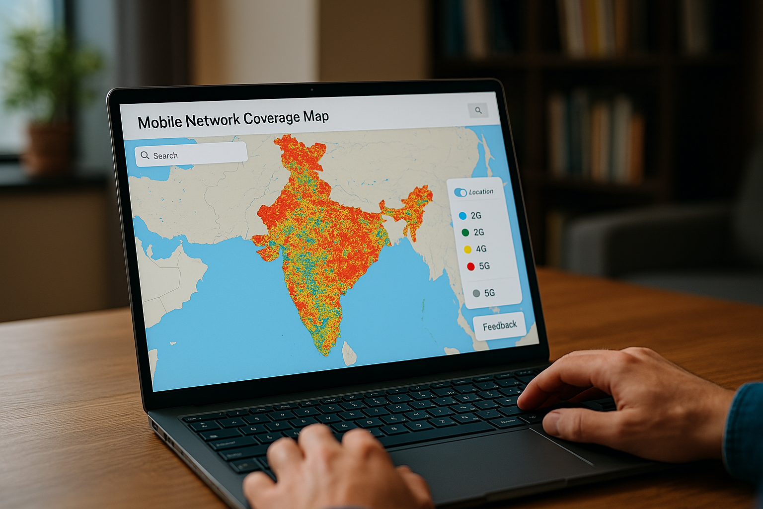
The publication of mobile network coverage maps by the TSPs is also aimed at helping customers make informed decisions when choosing their mobile service providers. These maps will allow users to visualize which areas are covered by different network technologies such as 2G, 3G, 4G, and 5G, thereby enabling them to assess the available services before making their subscriptions.
The coverage maps are now live on the websites of various TSPs. These maps come with a user-friendly interface, making it easier for mobile subscribers to access the relevant coverage data. Each map allows users to see coverage availability for different network technologies in specific geographical areas. To enhance usability, the maps also include features such as search options and the ability to enable location services on users’ devices, helping them to quickly view coverage in their current location.
A Standardized User Experience
One of the key features of the new coverage maps is the adoption of a standardized color scheme across all TSPs. This ensures that users can easily interpret the information, regardless of the service provider. The color-coding clearly differentiates between the different network technologies—2G, 3G, 4G, and 5G—allowing users to quickly identify which services are available in their area.
A toggle switch or technology selection button enables users to switch between different network coverage layers (2G, 3G, 4G, or 5G), providing them with a comprehensive view of the mobile network landscape. This feature is especially useful for customers looking to assess the coverage for specific technologies, such as the availability of high-speed 4G or the latest 5G services.
In addition to the color-coded maps, users are encouraged to share their feedback on any discrepancies they might notice. A feedback feature has been integrated into the maps, allowing users to report coverage issues directly to their service provider. This feedback mechanism ensures that the coverage data remains accurate and up to date, while also giving TSPs the opportunity to address any inaccuracies or gaps in service coverage.
Real-Time Coverage and User Engagement
While the mobile network coverage maps are a useful tool, it is important for users to note that the actual mobile coverage experience can sometimes vary from what is shown on the map. Factors such as indoor signal interference, local network congestion, and dynamic changes in service availability can impact the real-time coverage experience. Therefore, users are advised to use the maps as a reference rather than an absolute guarantee of mobile service availability in their area.
Despite these potential variations, the maps offer a broad overview of telecom coverage across the country, which serves as a vital resource for stakeholders involved in planning and rolling out future telecommunications infrastructure. The availability of this data helps various organizations, including government bodies, telecom regulators, and service providers, to identify areas that may require improvements or additional coverage, particularly in underserved or remote regions.
A Valuable Resource for Policy Planning
The mobile network coverage maps are also instrumental for government bodies and regulators involved in the planning and rollout of digital initiatives. By providing real-time coverage data, these maps enable regulators and policymakers to make data-driven decisions on the need for any regulatory or policy interventions. Moreover, the maps can be used to assess the progress of telecom infrastructure development across the country and to ensure equitable access to mobile services for all citizens, including those in rural and underserved areas.
How to Access the Coverage Maps
For easy access, the links to the mobile network coverage maps of different TSPs have been consolidated on the TRAI website. Users can access the maps by visiting the TRAI website (www.trai.gov.in), navigating to the “Consumer Info” section, and then clicking on the “Mobile Coverage Map” link. From there, they can select their preferred service provider and explore the coverage details in their area of interest.
Final Thoughts
The publication of mobile network coverage maps represents a significant step forward in enhancing transparency in the telecom sector. By offering users clear and accessible information about the availability of mobile services, TSPs are giving consumers the tools to make better-informed decisions regarding their mobile subscriptions. These coverage maps also empower users to report discrepancies and contribute to the accuracy of the data, fostering a more collaborative and transparent telecom ecosystem.
For further information or clarifications, mobile subscribers can contact Shri Tejpal Singh, Advisor (QoS-I) at TRAI, through email at adv-qos1@trai.gov.in or via phone at +91-11-20907759.


